Toronto Streetcar
Note 23-12-2021: Updated to make the trams compatible with Hageningen tram network in Metrosimulator 3.17, by adding "ROZ" (Rijden op Zicht / Drive on sight, as alternative to ATB and ZUB train protection). If you want to use these trams on the Hageningen tram network and you have downloaded this package before this date, please re-download.
Further change; in the Flexity tram, more information is shown for the benefit of the tram driver.
Warning: The ATB system in this version of the Toronto network is no longer compatible with tram packages pre-dating 23-12-2021, as new ATB signals are used to display switch position in the Toronto Flexity tram, which older tram add-ons cannot process. Updates for all tram addons are being prepared.
| Toronto Streetcar 509 Harbourfront & 510 Spadina |
|---|
509 Harbourfront and 510 Spadina are streetcar routes in Toronto, Canada, operated by the Toronto Transit Commission (TTC).
Line 509 has 12 stops, two of which underground.
Line 510 has 18 stops, three of which underground.
| The network |
|---|
|
General info Screenshot
Author:
Sjoerd Ydema
Lines:
2
Traction power supply:
overhead wire
Description:
Recreation of line 509 and 510 of the Toronto Streetcar system
MetroSim Version Required:
3.15
Download:
|
|---|

|
Network information
Lines
Depots
Train-Protection Systems
Train usage
|
|---|


|
Line 509
Line 509 Harbourfront runs between Union Station and Exhibition, over a distance of approximately 4,1 kilometers. The line has 12 stops, of which two are underground (Unions Station and Queens Quay).
Unlike most other streetcar routes ("streetcar" = tram) in Toronto, the 509 Harbourfront runs over its full length on separated tracks (right-of-way); aside from road crossings, the streetcars do not run between other traffic.
|
||||||||||||||||||||||||||||||||||||||||||||||||||||||||||||||||||||||||||||||||||||||||||||||
|---|---|---|---|---|---|---|---|---|---|---|---|---|---|---|---|---|---|---|---|---|---|---|---|---|---|---|---|---|---|---|---|---|---|---|---|---|---|---|---|---|---|---|---|---|---|---|---|---|---|---|---|---|---|---|---|---|---|---|---|---|---|---|---|---|---|---|---|---|---|---|---|---|---|---|---|---|---|---|---|---|---|---|---|---|---|---|---|---|---|---|---|---|---|---|
|
Line 510
Line 510 Spaina runs between Spadina Station and Union Station, over a distance of approximately 6 kilometers. The line has 18 stops, of which three are underground (Spadina Station, Queens Quay and Union Station).
Unlike most other streetcar routes ("streetcar" = tram) in Toronto, the 510 Spadina runs over its full length on separated tracks (right-of-way); aside from road crossings, the streetcars do not run between other traffic. |
||||||||||||||||||||||||||||||||||||||||||||||||||||||||||||||||||||||||||||||||||||||||||||||||||||||||||||||||||||||
|---|---|---|---|---|---|---|---|---|---|---|---|---|---|---|---|---|---|---|---|---|---|---|---|---|---|---|---|---|---|---|---|---|---|---|---|---|---|---|---|---|---|---|---|---|---|---|---|---|---|---|---|---|---|---|---|---|---|---|---|---|---|---|---|---|---|---|---|---|---|---|---|---|---|---|---|---|---|---|---|---|---|---|---|---|---|---|---|---|---|---|---|---|---|---|---|---|---|---|---|---|---|---|---|---|---|---|---|---|---|---|---|---|---|---|---|---|---|---|
|
Rolling stock
Two types of rolling stock are being used on this line; the older CLRV Canadian Light Rail Vehicle and ALRV Articulated Light Rail Vehicle, and the more modern Bombardier Flexity Outlook tram.
|
|---|
|
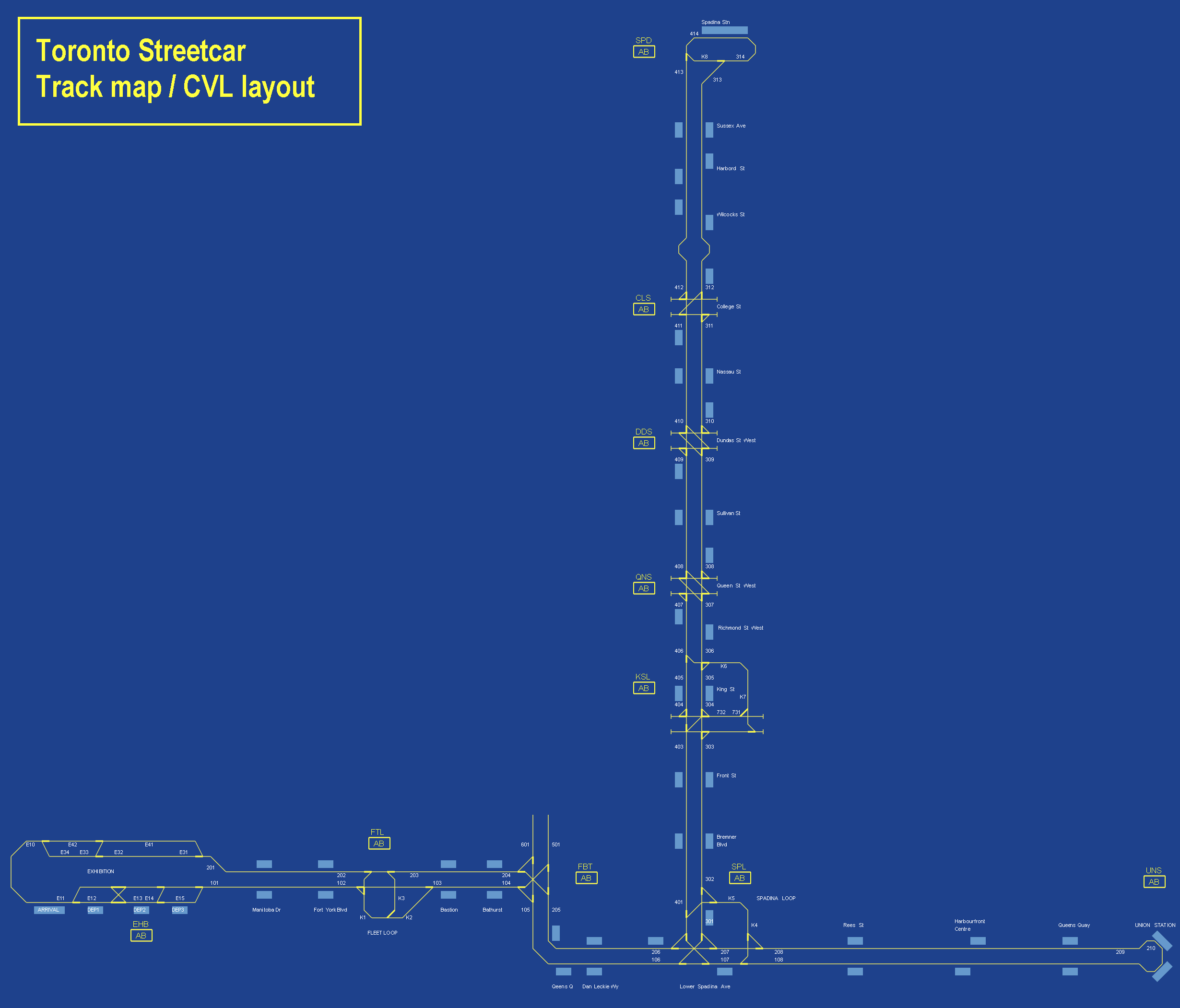
Track layout
The image below shows the track layout as it appears in the CVL screen.
|
|---|
|
Signalling system
As driving on sight is not an option in Metrosimulator, a fixed block system has been installed on the line, with ATB train protection. The allowed speeds are being shown on the driver panel, and enforced by the system. If the next block is occupied, or switches have not been set, the maximum speed is 10 km/h. In this case, you may not pass the next "S"-sign next to the tracks, which indicate the block separations, until you get a higher indicated speed limit (even if traffic lights are already green). The blocks have been kept short to allow short following distances.
Even though the transit signal has a double layout, these are not double signals; both lights are for the same direction.
|
|---|


|
External links
Website of the TTC: https://www.ttc.ca/
|
|---|
Special thanks
The line is being created for use in Metrosimulator, in partnership with T2P Films Developments (https://developments.t2pfilms.ca/Downloads.html), who are providing a number of 3D objects for the simulation.
![]()