Rijndam 2006: Difference between revisions
mNo edit summary |
mNo edit summary |
||
| (6 intermediate revisions by 4 users not shown) | |||
| Line 1: | Line 1: | ||
{{Header|Rijndam}} | {{Header|Rijndam}} | ||
Rijndam is a fictional city in Dutch style (made by Sjoerd Ydema), located along the river Rhine, with a metro network inspired by several different Dutch and non-Dutch metro networks. | |||
There are seven versions of the Rijndam network; | |||
There are | |||
*[[Rijndam_1985|Rijndam 1985]] | *[[Rijndam_1985|Rijndam 1985]] | ||
*[[Rijndam_2006|Rijndam 2006]] | *[[Rijndam_2006|Rijndam 2006]] | ||
| Line 13: | Line 10: | ||
*[[Rijndam_2020|Rijndam 2020]] | *[[Rijndam_2020|Rijndam 2020]] | ||
*[[Rijndam_2022|Rijndam 2022]] | *[[Rijndam_2022|Rijndam 2022]] | ||
*[[Rijndam Railways 2022]] | |||
{{Header|Rijndam 2006}} | {{Header|Rijndam 2006}} | ||
| Line 19: | Line 16: | ||
[[File:Rijndam_Metro_wandkaart_2006.png|1000px]] | [[File:Rijndam_Metro_wandkaart_2006.png|1000px]] | ||
[[File:Rijndam_Metro_wandkaart_treindienst_2006.png|350px]] | [[File:Rijndam_Metro_wandkaart_treindienst_2006.png|350px]] | ||
<table style="float:right;"> | <table style="float:right;"> | ||
<tr> | |||
<th colspan="4" width="330px" valign="top" style="border: 1px solid #B8B8B8; padding: 7px;"> | |||
<div id="mf-infoheader" style="padding:5px;background:#1045e5;color:white;font-size:120%;">General info</div> | <div id="mf-infoheader" style="padding:5px;background:#1045e5;color:white;font-size:120%;">General info</div> | ||
<br | <br><div id="mf-infoheader" style="padding:5px;background:silver;color:white;font-size:110%;">Rijndam 2006</div> | ||
[[File:Rijndam_Metrokaart_2006.png|330px]] | [[File:Rijndam_Metrokaart_2006.png|330px]] | ||
<br | <br><div id="mf-infoheader" style="padding:5px;background:silver;color:white;font-size:110%;">Screenshot</div> | ||
[[File:Rijndam_199.jpg|330px]]<br | [[File:Rijndam_199.jpg|330px]]<br><br> | ||
<div id="mf-infoheader" style="padding:2px;background:gray;color:white;font-size:85%;">'''Author:'''</div> | <div id="mf-infoheader" style="padding:2px;background:gray;color:white;font-size:85%;">'''Author:'''</div> | ||
<div id="mf-infoheader" style="padding:2px;background:white;color:black;font-size:85%;">Sjoerd Ydema</div> | <div id="mf-infoheader" style="padding:2px;background:white;color:black;font-size:85%;">Sjoerd Ydema</div> | ||
| Line 46: | Line 38: | ||
<div id="mf-infoheader" style="padding:2px;background:gray;color:white;font-size:85%;">'''Download:'''</div> | <div id="mf-infoheader" style="padding:2px;background:gray;color:white;font-size:85%;">'''Download:'''</div> | ||
<div id="mf-infoheader" style="padding:2px;background:white;color:black;font-size:85%;">N/A, Build-in</div> | <div id="mf-infoheader" style="padding:2px;background:white;color:black;font-size:85%;">N/A, Build-in</div> | ||
</th> | |||
</tr> | |||
</table> | </table> | ||
<table style="float:left;width:50%;"> | <table style="float:left;width:50%;"> | ||
<tr> | |||
<th colspan="4" valign="top" style="border: 1px solid #B8B8B8; padding: 7px;"> | |||
<div id="mf-infoheader" style="padding:5px;background:#109EE5;color:white;font-size:120%;">Network information</div> | <div id="mf-infoheader" style="padding:5px;background:#109EE5;color:white;font-size:120%;">Network information</div> | ||
<br | <br><div id="mf-infoheader" style="padding:5px;background:silver;color:white;font-size:110%;">Lines</div> | ||
<div id="mf-info" style="padding-top: 10px; padding-left: 1em; color: grey; text-align: left;"> | <div id="mf-info" style="padding-top: 10px; padding-left: 1em; color: grey; text-align: left;"> | ||
There are 4 main lines, an airport shuttleservice, and a small museumline: | There are 4 main lines, an airport shuttleservice, and a small museumline: | ||
*Line M1: Molenwijk - Noorderpoort / Noorderpoort - Panbos | *Line M1: Molenwijk - Noorderpoort / Noorderpoort - Panbos | ||
*Line M2: Central Station - Monument | *Line M2: Central Station - Monument | ||
| Line 65: | Line 56: | ||
*Airport Shuttleservice: Airport Terminal 4 - P40 Parking | *Airport Shuttleservice: Airport Terminal 4 - P40 Parking | ||
</div> | </div> | ||
<br | <br><div id="mf-infoheader" style="padding:5px;background:silver;color:white;font-size:110%;">Depots</div> | ||
<div id="mf-info" style="padding-top: 10px; padding-left: 1em; color: grey; text-align: left;"> | <div id="mf-info" style="padding-top: 10px; padding-left: 1em; color: grey; text-align: left;"> | ||
The network has several depots: | The network has several depots: | ||
| Line 72: | Line 63: | ||
*Depot Rijndam Airport | *Depot Rijndam Airport | ||
</div> | </div> | ||
<br | <br><div id="mf-infoheader" style="padding:5px;background:silver;color:white;font-size:110%;">Train-Protection Systems</div> | ||
<div id="mf-info" style="padding-top: 10px; padding-left: 1em; color: grey; text-align: left;"> | <div id="mf-info" style="padding-top: 10px; padding-left: 1em; color: grey; text-align: left;"> | ||
[[ATB]] on line M1 (MLW-NDP), M2, M3 and museum shuttle. <br | [[ATB]] on line M1 (MLW-NDP), M2, M3 and museum shuttle. <br><br> | ||
[[ZUB]] on line M1 (NDP-PNB) and M4 | [[ZUB]] on line M1 (NDP-PNB) and M4 | ||
</div> | </div> | ||
<br | <br><div id="mf-infoheader" style="padding:5px;background:silver;color:white;font-size:110%;">Train usage</div> | ||
<div id="mf-info" style="padding-top: 10px; padding-left: 1em; color: grey; text-align: left;"> | <div id="mf-info" style="padding-top: 10px; padding-left: 1em; color: grey; text-align: left;"> | ||
Lines M1, M2 and M3 <br | Lines M1, M2 and M3 <br> [[File:SG2-Side.png|link=SG2|275px]] <br><br> Lines M1 and M4 <br> [[File:RSG2-Side.png|link=RSG2|275px]] <br><br> Lines M1 <br> [[File:MG2-side.png|link=MG2|275px]] <br> | ||
</div> | </div> | ||
</th> | |||
</tr> | |||
</table> | </table> | ||
<br style="clear:both;"/> | <br style="clear:both;"/> | ||
<table> | <table> | ||
<tr> | |||
<th colspan="4" width="100%" valign="top" style="border: 1px solid #B8B8B8; padding: 7px;"> | |||
<div id="mf-infoheader" style="width: 400px;padding:5px;background:#109EE5;color:white;font-size:120%;">Lines</div> | <div id="mf-infoheader" style="width: 400px;padding:5px;background:#109EE5;color:white;font-size:120%;">Lines</div> | ||
<div id="mf-info" style="padding-top: 10px; padding-left: 1em; color: grey; text-align: left;"> | <div id="mf-info" style="padding-top: 10px; padding-left: 1em; color: grey; text-align: left;"> | ||
| Line 95: | Line 84: | ||
== Line M1 == | == Line M1 == | ||
{{Navigatie M1}} | {{Navigatie M1}} | ||
Line M1 runs above ground from Molenwijk to Simvlietlaan and from Nobelplein to Panbos. Between Simvlietlaan and Nobelplein, line M1 runs underground. | Line M1 runs above ground from Molenwijk to Simvlietlaan and from Nobelplein to Panbos. Between Simvlietlaan and Nobelplein, line M1 runs underground. | ||
The section from Nobelplein to Panbos was once a local railwayline, starting at a station at Rijndam Noorderpoort. Last year, the Rijndam city council has decided to connect this railway to the metro network. This was done to eliminate the need for passenger interchange, to increase the frequency of services on the line, and to allow for the demolition and redevelopment of the site of the former train station. <br | The section from Nobelplein to Panbos was once a local railwayline, starting at a station at Rijndam Noorderpoort. Last year, the Rijndam city council has decided to connect this railway to the metro network. This was done to eliminate the need for passenger interchange, to increase the frequency of services on the line, and to allow for the demolition and redevelopment of the site of the former train station. <br> | ||
Power on this section is supplied by overhead whires; at Nobelplein, line M1 metro's switch from 3rd rail to overhead power supply. | Power on this section is supplied by overhead whires; at Nobelplein, line M1 metro's switch from 3rd rail to overhead power supply. | ||
From Noorderpoort to Panbos, line M1 runs under ZUB train protection. For this the RSG2 rolling stock is used; passengers need to change at Noorderpoort. | From Noorderpoort to Panbos, line M1 runs under ZUB train protection. For this the RSG2 rolling stock is used; passengers need to change at Noorderpoort. | ||
Destination codes: | Destination codes: | ||
M - Molenwijk | *M - Molenwijk | ||
C - Central Station | *C - Central Station | ||
P - Noorderpoort | *P - Noorderpoort | ||
V - Noordvliet | *V - Noordvliet | ||
B - Panbos | *B - Panbos | ||
== Line M2 == | == Line M2 == | ||
{{Navigatie M2 2016}} | {{Navigatie M2 2016}} | ||
Line M2 runs underground from Central Station to Westpoort. After Westpoort, the line continues above ground to Station Westplein and Monument. At Station Westplein, metro's switch to Sneltram mode for the last part to Monument. | Line M2 runs underground from Central Station to Westpoort. After Westpoort, the line continues above ground to Station Westplein and Monument. At Station Westplein, metro's switch to Sneltram mode for the last part to Monument. | ||
Metro's on line M2 in the direction Central Station will switch to line M3 upon arriving. | |||
Metro's on line M2 in the direction Central Station will switch to line M3 upon arriving. | |||
Destination codes: | |||
G - Central Station via National Opera | Destination codes: | ||
S - Station Westplein | *G - Central Station via National Opera | ||
O - Monument | *S - Station Westplein | ||
*O - Monument | |||
== Line M3 == | == Line M3 == | ||
{{Navigatie M3 2016}} | {{Navigatie M3 2016}} | ||
Line M3 runs underground from Central Station to Westpoort. After Westpoort, the line continues above ground to Station Westplein and Rijnland Ziekenhuis (Hospital). At Station Westplein, metro's switch to Sneltram mode for the last part to Rijnland Hospital. | Line M3 runs underground from Central Station to Westpoort. After Westpoort, the line continues above ground to Station Westplein and Rijnland Ziekenhuis (Hospital). At Station Westplein, metro's switch to Sneltram mode for the last part to Rijnland Hospital. | ||
Metro's on line M3 in the direction Central Station will switch to line M2 upon arriving. | |||
Metro's on line M3 in the direction Central Station will switch to line M2 upon arriving. | |||
Destination codes: | |||
C - Central Station via Garenmarkt | Destination codes: | ||
S - Station Westplein | *C - Central Station via Garenmarkt | ||
R - Rijnland Ziekenhuis (Hospital) | *S - Station Westplein | ||
*R - Rijnland Ziekenhuis (Hospital) | |||
== Line M4 == | == Line M4 == | ||
{{Navigatie M4 2006}} | {{Navigatie M4 2006}} | ||
Line M4 connects the city with Rijndam Airport. It starts at Noorderpoort, and runs above ground to Rijndam Airport. Shortly before reaching the aiport, the line returns underground, to terminate under the Airport terminal building containing terminals 1,2 and 3 (passengers for terminal 4 can change here for a shuttle service). | Line M4 connects the city with Rijndam Airport. It starts at Noorderpoort, and runs above ground to Rijndam Airport. Shortly before reaching the aiport, the line returns underground, to terminate under the Airport terminal building containing terminals 1,2 and 3 (passengers for terminal 4 can change here for a shuttle service). | ||
As with line M1, the section outside of the city uses a converted railway line, with power supply by overhead whires (the switch from 3rd rail to overhead whires is done after the line surfaces leaving Noorderpoort) and ZUB train protection. Near the tunnel entrance, a small portion of the former connection to the old site of the Noorderpoort Train station can still be seen. | |||
As with line M1, the section outside of the city uses a converted railway line, with power supply by overhead whires (the switch from 3rd rail to overhead whires is done after the line surfaces leaving Noorderpoort) and ZUB train protection. Near the tunnel entrance, a small portion of the former connection to the old site of the Noorderpoort Train station can still be seen. | |||
Line M4 has its depot at the airport, using the site of a former underground cargo terminal. | |||
Destination codes: | |||
*P - Noorderpoort | |||
Destination codes: | *A - Rijndam Airport | ||
P - Noorderpoort | |||
A - Rijndam Airport | |||
== Museumline == | == Museumline == | ||
{{Navigatie Museumlijn}} | {{Navigatie Museumlijn}} | ||
The metro transport museum is located at the Wagenmakerstraat in Noordvliet, at the end of a old freight branch off the Rijndam - Panbos line. Here, a small depot has been build in order to preserve, maintain and display the historic metro trains. The line connecting the museum to the nearby Noordvliet station (on line M1) has been converted for use by these old metro trains; it has 3rd rail power supply and ATB train protection. | The metro transport museum is located at the Wagenmakerstraat in Noordvliet, at the end of a old freight branch off the Rijndam - Panbos line. Here, a small depot has been build in order to preserve, maintain and display the historic metro trains. The line connecting the museum to the nearby Noordvliet station (on line M1) has been converted for use by these old metro trains; it has 3rd rail power supply and ATB train protection. | ||
Destination codes: | |||
*V - Noordvliet | |||
*W - Transport museum | |||
== Airport Shuttleservice == | == Airport Shuttleservice == | ||
{{Navigatie Airport Shuttleservice 2006}} | {{Navigatie Airport Shuttleservice 2006}} | ||
The Airport Shuttleservice is a short line connecting the airport terminals with several parking lots near the airport. It is operated by the Airport Authority, separate from the Rijndam metro network. The line is provided as a free service to passengers. At Rijndam Airport Terminals 1-3 passengers can transfer to/from the Rijndam Metro network, line M4. | The Airport Shuttleservice is a short line connecting the airport terminals with several parking lots near the airport. It is operated by the Airport Authority, separate from the Rijndam metro network. The line is provided as a free service to passengers. At Rijndam Airport Terminals 1-3 passengers can transfer to/from the Rijndam Metro network, line M4. | ||
It is a single track line, electrified with 3rd rail, and equipped with ATB train protection. The platforms are shorter then those on the Rijndam metro network; only 60 meters, long enough for two SG2 units. The line has it's own depot, located near the stop "P40 Parking". At the stop Airport Control, metro's from the opposite direction can be passed. | |||
It is a single track line, electrified with 3rd rail, and equipped with ATB train protection. The platforms are shorter then those on the Rijndam metro network; only 60 meters, long enough for two SG2 units. The line has it's own depot, located near the stop "P40 Parking". At the stop Airport Control, metro's from the opposite direction can be passed. | |||
Destination codes: | |||
*F - Airport Terminal 4 | |||
*Q - P40 Parking | |||
*Z - Depot | |||
</div> | </div> | ||
</th> | |||
</tr> | |||
</table> | </table> | ||
<table> | <table> | ||
<tr> | |||
<th colspan="4" width="100%" valign="top" style="border: 1px solid #B8B8B8; padding: 7px;"> | |||
<div id="mf-infoheader" style="width: 400px;padding:5px;background:#109EE5;color:white;font-size:120%;">Other locations</div> | <div id="mf-infoheader" style="width: 400px;padding:5px;background:#109EE5;color:white;font-size:120%;">Other locations</div> | ||
<div id="mf-info" style="padding-top: 10px; padding-left: 1em; color: grey; text-align: left;"> | <div id="mf-info" style="padding-top: 10px; padding-left: 1em; color: grey; text-align: left;"> | ||
== Depots == | == Depots == | ||
=== Depot Molenwijk === | === Depot Molenwijk === | ||
Depot Molenwijk is the main depot on the network. It is situated near the terminus Molenwijk at line M1. It has 13 sidings for stabling up to 100 SG3-type metro trains, a 4-track maintenance facility, a track for testing trains, and a mainline railway connection for receiving or sending cargo. | Depot Molenwijk is the main depot on the network. It is situated near the terminus Molenwijk at line M1. It has 13 sidings for stabling up to 100 SG3-type metro trains, a 4-track maintenance facility, a track for testing trains, and a mainline railway connection for receiving or sending cargo. | ||
=== Depot Bergenseweg === | === Depot Bergenseweg === | ||
Depot Bergenseweg is a former freightyard near Bergenseweg metro station, connected to the metro network at Station Westplein. After the national railway company abandoned it, it has been closed off from the main railway line, and converted for use by the Rijndam metro network (power supply by overhead whires). Three tracks have been converted to serve as stabling facility for metro trains. The other tracks are not electrified and are available for stabling track maintenance rolling stock and/or out-of-service metro trains. There is also a short section of track leading to the docks at the Rhine river. | Depot Bergenseweg is a former freightyard near Bergenseweg metro station, connected to the metro network at Station Westplein. After the national railway company abandoned it, it has been closed off from the main railway line, and converted for use by the Rijndam metro network (power supply by overhead whires). Three tracks have been converted to serve as stabling facility for metro trains. The other tracks are not electrified and are available for stabling track maintenance rolling stock and/or out-of-service metro trains. There is also a short section of track leading to the docks at the Rhine river. | ||
=== Depot Rijndam Airport === | === Depot Rijndam Airport === | ||
Depot Rijndam Airport uses the site of a former underground cargo terminal. It has 4 tracks. It is the only fully underground depot on the network. | Depot Rijndam Airport uses the site of a former underground cargo terminal. It has 4 tracks. It is the only fully underground depot on the network. | ||
</div> | </div></th></tr></table> | ||
</table> | |||
<table> | <table><tr><th colspan="4" width="100%" valign="top" style="border: 1px solid #B8B8B8; padding: 7px;"> | ||
<div id="mf-infoheader" style="width: 400px;padding:5px;background:#109EE5;color:white;font-size:120%;">Misc</div> | <div id="mf-infoheader" style="width: 400px;padding:5px;background:#109EE5;color:white;font-size:120%;">Misc</div> | ||
<div id="mf-info" style="padding-top: 10px; padding-left: 1em; color: grey; text-align: left;"> | <div id="mf-info" style="padding-top: 10px; padding-left: 1em; color: grey; text-align: left;"> | ||
== Railwaylines signals and security == | |||
The railway lines in the Rijndam network are equiped with Dutch railway signals and [https://en.wikipedia.org/wiki/Automatische_treinbe%C3%AFnvloeding ATB-EG] security. | |||
The signs along the tracks are mostly the same as the signs used on the metro network, but there are a few differences. For example, the numbers on the blue stopsigns are in carriages of train length instead of the number of trainsets (a two-part train will stop at stopsign 2 on the railway network, where a MG2/SG2 metro will stop at stopsign 1 on the metro network). | |||
The following signals are being used to provide information on track clearance and speed limits; | |||
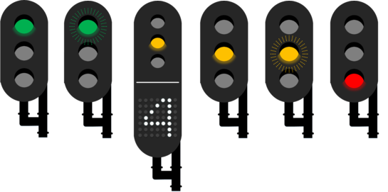
= | [[File:Seinen.png|600px|link=http://sim.bemined.nl/w/images/b/b4/Seinen.png]] | ||
*<span style="color:#00b050">Green:</span> Proceed at local maximum speed. | |||
*<span style="color:#00b050">Green flashing:</span> Proceed at a maximum of 40 km/h. If the number 6 is displayed below the light, proceed at 60 km/h. | |||
< | *<span style="color:#fec000">Yellow + 4:</span> Slow down to 40 km/h. The next signal will not be red, but you must have slowed to 40 km/h before passing it. | ||
The | *<span style="color:#fec000">Yellow + 6:</span> Slow down to 60 km/h. The next signal will not be red, but you must have slowed to 60 km/h before passing it. | ||
< | *<span style="color:#fec000">Yellow:</span> Slow down to 40 km/h and be prepared to stop at the next signal. | ||
*<span style="color:#fec000">Yellow flashing:</span> Drive on sight; you are entering a track which is already occupied (or outside the controlled area). Pass at a maximum of 40 km/h, and be prepared to stop at any time. | |||
*<span style="color:#ff0000">Red:</span> Stop. | |||
The signals are backed up by ATB-EG security, controlling the maximum speed on the line. The signals are relayed to the trains by using the tracks to create a series of electromagnetic pulses, which are recognised by the equipment on board the trains. The ATB-EG system controlls the maximum speeds 40, 60, 80 and 130 km/h. | |||
However, the main rule remains "when more then one speed indication is given, the most restrictive one must be followed". So when signs along the track tell you the maximum speed is 100 km/h, and the ATB tells you 130, then you must keep to 100 km/h. | |||
However, the main rule remains "when more then one speed indication is given, the most restrictive one must be followed". So when signs along the track tell you the maximum speed is 100 km/h, and the ATB tells you 130, then you must keep to 100 km/h. | |||
The metro rolling stock will display (and enforce) the highest speed they can at or below the speed they receive from the ATB-EG; for example, if the ATB-EG sends out "130 km/h", the SG3 rolling stock will display "100", and the Bursa 5200's will display "80". | The metro rolling stock will display (and enforce) the highest speed they can at or below the speed they receive from the ATB-EG; for example, if the ATB-EG sends out "130 km/h", the SG3 rolling stock will display "100", and the Bursa 5200's will display "80". | ||
== Railway Sprinter service == | == Railway Sprinter service == | ||
{{Navigatie RR1 2006}} | {{Navigatie RR1 2006}} | ||
{{Navigatie RR2 2006}} | {{Navigatie RR2 2006}} | ||
The Railway Sprinter service (also known as "Rijndam Rail") runs from Rijndam Central Station to Rijndam Buitenvelden, and from Rijndam Central Station to Denia. | The Railway Sprinter service (also known as "Rijndam Rail") runs from Rijndam Central Station to Rijndam Buitenvelden, and from Rijndam Central Station to Denia. | ||
Tickets from the metro network are also valid on the Railway Sprinter service. | |||
Trivia: | |||
*As no railway passenger rolling stock is available in Metrosimulator, the Railway Sprinter service makes use of specially adapted SG3 rolling stock; the (fictional) RijndamRail SG4. An RijndamRail SG4 has the same length as a two-part train (types SGM / Plan V) of the Dutch Railways; in the simulation, stop a single SG4 at stopsign "2" at the railwaystations. | |||
*The freighttrain runs between Molenwijk and Buitenvelden, using destinationcode "N" in activities. Allowing the freighttrain to run in explore mode (it is automatically placed in the network) requires loading the Rijndam2006.CTD file, and setting a train code with destination "N" (like "9911NN"). At the beginning of the simulation, the freighttrain can be found at the Buitenvelden turning loop with train code F10001. | |||
N | |||
N | |||
</div> | Destination codes: | ||
*C - Rijndam Central Station | |||
*S - Rijndam Westplein | |||
</table> | *Y - Rijndam Buitenvelden | ||
*T - Rijndam Zuid | |||
*D - Denia | |||
*N - Freight train loop (Molenwijk - CS (track 1-3) - Buitenvelden v.v.) | |||
*N - Secundairy loop (Central Station (track 4-6) - Rijndam Zuid v.v.) | |||
</div></th></tr></table> | |||
{{Navigatie Rijndam}} | {{Navigatie Rijndam}} | ||
{{Template:Navigatie Routes}} | {{Template:Navigatie Routes}} | ||
Latest revision as of 11:40, 9 July 2020
| Rijndam |
|---|
Rijndam is a fictional city in Dutch style (made by Sjoerd Ydema), located along the river Rhine, with a metro network inspired by several different Dutch and non-Dutch metro networks.
There are seven versions of the Rijndam network;
| Rijndam 2006 |
|---|


|
General info
Rijndam 2006
Screenshot
Author:
Sjoerd Ydema
Lines:
5
Traction power supply:
Third rail (in the city centre and Museum Shuttle) and Overhead wire (in the Suburbs)
Description:
Rijndam metro network in 2006. Contains 4 lines and a Museum Shuttle. M2 and M3 run on Sneltram sections
MetroSim Version Required:
Beta 3.12
Download:
N/A, Build-in
|
|---|


|
Network information
Lines
There are 4 main lines, an airport shuttleservice, and a small museumline:
Depots
The network has several depots:
Train-Protection Systems
Train usage
Lines M1, M2 and M3 |
|---|
|
Lines
Line M1Line M1 runs above ground from Molenwijk to Simvlietlaan and from Nobelplein to Panbos. Between Simvlietlaan and Nobelplein, line M1 runs underground. The section from Nobelplein to Panbos was once a local railwayline, starting at a station at Rijndam Noorderpoort. Last year, the Rijndam city council has decided to connect this railway to the metro network. This was done to eliminate the need for passenger interchange, to increase the frequency of services on the line, and to allow for the demolition and redevelopment of the site of the former train station. From Noorderpoort to Panbos, line M1 runs under ZUB train protection. For this the RSG2 rolling stock is used; passengers need to change at Noorderpoort. Destination codes:
Line M2Line M2 runs underground from Central Station to Westpoort. After Westpoort, the line continues above ground to Station Westplein and Monument. At Station Westplein, metro's switch to Sneltram mode for the last part to Monument. Metro's on line M2 in the direction Central Station will switch to line M3 upon arriving. Destination codes:
Line M3Line M3 runs underground from Central Station to Westpoort. After Westpoort, the line continues above ground to Station Westplein and Rijnland Ziekenhuis (Hospital). At Station Westplein, metro's switch to Sneltram mode for the last part to Rijnland Hospital. Metro's on line M3 in the direction Central Station will switch to line M2 upon arriving. Destination codes:
Line M4Line M4 connects the city with Rijndam Airport. It starts at Noorderpoort, and runs above ground to Rijndam Airport. Shortly before reaching the aiport, the line returns underground, to terminate under the Airport terminal building containing terminals 1,2 and 3 (passengers for terminal 4 can change here for a shuttle service). As with line M1, the section outside of the city uses a converted railway line, with power supply by overhead whires (the switch from 3rd rail to overhead whires is done after the line surfaces leaving Noorderpoort) and ZUB train protection. Near the tunnel entrance, a small portion of the former connection to the old site of the Noorderpoort Train station can still be seen. Line M4 has its depot at the airport, using the site of a former underground cargo terminal. Destination codes:
MuseumlineThe metro transport museum is located at the Wagenmakerstraat in Noordvliet, at the end of a old freight branch off the Rijndam - Panbos line. Here, a small depot has been build in order to preserve, maintain and display the historic metro trains. The line connecting the museum to the nearby Noordvliet station (on line M1) has been converted for use by these old metro trains; it has 3rd rail power supply and ATB train protection. Destination codes:
Airport ShuttleserviceThe Airport Shuttleservice is a short line connecting the airport terminals with several parking lots near the airport. It is operated by the Airport Authority, separate from the Rijndam metro network. The line is provided as a free service to passengers. At Rijndam Airport Terminals 1-3 passengers can transfer to/from the Rijndam Metro network, line M4. It is a single track line, electrified with 3rd rail, and equipped with ATB train protection. The platforms are shorter then those on the Rijndam metro network; only 60 meters, long enough for two SG2 units. The line has it's own depot, located near the stop "P40 Parking". At the stop Airport Control, metro's from the opposite direction can be passed. Destination codes:
|
|||||||||||||||||||||||||||||||||
|---|---|---|---|---|---|---|---|---|---|---|---|---|---|---|---|---|---|---|---|---|---|---|---|---|---|---|---|---|---|---|---|---|---|
|
Other locations
DepotsDepot MolenwijkDepot Molenwijk is the main depot on the network. It is situated near the terminus Molenwijk at line M1. It has 13 sidings for stabling up to 100 SG3-type metro trains, a 4-track maintenance facility, a track for testing trains, and a mainline railway connection for receiving or sending cargo. Depot BergensewegDepot Bergenseweg is a former freightyard near Bergenseweg metro station, connected to the metro network at Station Westplein. After the national railway company abandoned it, it has been closed off from the main railway line, and converted for use by the Rijndam metro network (power supply by overhead whires). Three tracks have been converted to serve as stabling facility for metro trains. The other tracks are not electrified and are available for stabling track maintenance rolling stock and/or out-of-service metro trains. There is also a short section of track leading to the docks at the Rhine river. Depot Rijndam AirportDepot Rijndam Airport uses the site of a former underground cargo terminal. It has 4 tracks. It is the only fully underground depot on the network. |
|---|
|
Misc
Railwaylines signals and securityThe railway lines in the Rijndam network are equiped with Dutch railway signals and ATB-EG security. The signs along the tracks are mostly the same as the signs used on the metro network, but there are a few differences. For example, the numbers on the blue stopsigns are in carriages of train length instead of the number of trainsets (a two-part train will stop at stopsign 2 on the railway network, where a MG2/SG2 metro will stop at stopsign 1 on the metro network). The following signals are being used to provide information on track clearance and speed limits;
The signals are backed up by ATB-EG security, controlling the maximum speed on the line. The signals are relayed to the trains by using the tracks to create a series of electromagnetic pulses, which are recognised by the equipment on board the trains. The ATB-EG system controlls the maximum speeds 40, 60, 80 and 130 km/h. However, the main rule remains "when more then one speed indication is given, the most restrictive one must be followed". So when signs along the track tell you the maximum speed is 100 km/h, and the ATB tells you 130, then you must keep to 100 km/h. The metro rolling stock will display (and enforce) the highest speed they can at or below the speed they receive from the ATB-EG; for example, if the ATB-EG sends out "130 km/h", the SG3 rolling stock will display "100", and the Bursa 5200's will display "80". Railway Sprinter serviceThe Railway Sprinter service (also known as "Rijndam Rail") runs from Rijndam Central Station to Rijndam Buitenvelden, and from Rijndam Central Station to Denia. Tickets from the metro network are also valid on the Railway Sprinter service. Trivia:
Destination codes:
| |||||||||||||
|---|---|---|---|---|---|---|---|---|---|---|---|---|---|
| Editions |  | |
|---|---|---|
| Metro lines | ||
| Tram lines | ||
| RijndamRail lines | ||
| Other lines | ||
| Depots | ||
| Other locations | ||